After our longest, most strenuous leg in the wilderness yet, we are relaxing in Mammoth Lakes, CA, for the day and taking care of our weekly town chores. This past leg from Kearsarge Pass to Reds Meadow was another full of deep snow and swift, belly button deep, frigid snow-melt rivers. On top of the elements, there were often little to no tracks to follow in the snow, as very few people have done this section ahead of us. A great number of the hikers have been skipping sections of the High Sierra due to the swelled rivers and excessive snow, leaving us with the lead of the pack for now. To say the least, it has been very physically demanding and exhausting, but we both have definitely enjoyed the adventure and grandeur of every day in this humbling wilderness!
6/21
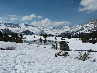
After a night at the Comfort Inn in Bishop with 10 other stinky hikers, we were ready to hit the trail again. We took a bus back to Independence and caught two quick hitches that brought us back to the Onion Valley Trailhead. Being the Summer Solstice, most hikers celebrate by hiking nude. We saw two nude hikers today, unfortunately not of the opposite sex, and we were glad we didn't run into any more. Quite the site! We pushed back out Kearsarge quickly and were back on the PCT. We lost the trail momentarily, but found it as we approached Glen Pass (11,900 ft). After a steep ascent on snow and some rock scrambling, we summited around 4 PM. We decided to posthole about 3 miles, found the first dry ground, and made camp. No-bake cheesecake was our reward for the Solstice and will most likely make its way into our packs for the first night out of town for the rest of the summer. Delicious! 9 Kearsarge miles, 6 PCT miles, 796 miles S->N
 |
| View of Kearsarge Pinnacles from Kearsarge Pass |
 |
| Forest at the Rae Lakes below Glen Pass |
 |
| One of the Frozen Rae Lakes with Fin Dome in Backdrop |
 |
| The Glorious No-bake Cheesecake! |
6/22
We decided to wake up early (5 AM) to try and not posthole so much in the afternoon. We had a wake-up shot as we forded icy and fast Woods Creek by 6:30 AM. After the ford, we descended 1500 feet on icy tracks and crossed Woods Creek again, this time on a beautiful suspension bridge. We climbed for the next 7 miles (it felt like 20 miles) along Woods Creek. The river was flowing through snow tunnels and was beautiful in the morning light. We had another steep climb up to Pinchot Pass, requiring ice axes. We lunched atop the pass at 12,130 feet, descended past gorgeous alpine lakes, and practically slid all the way down to the South Fork King River. By far the scariest river we encountered to date, we crossed slippery logs and through rapid, icy water and made camp quickly, glad to be done with the river. 17 miles, 812 miles S->N
 |
| Woods Creek Bridge |
 |
| Woods Creek |
 |
| Atop Pinchot Pass |
 |
| Our Chipmunk Buddy on Pinchot |
 | | |
| Dropping Down from the Pass | | |
|
 |
| Part One of the South Fork King River Crossing |
 |
| Part Two of the South Fork King River Crossing |
6/23
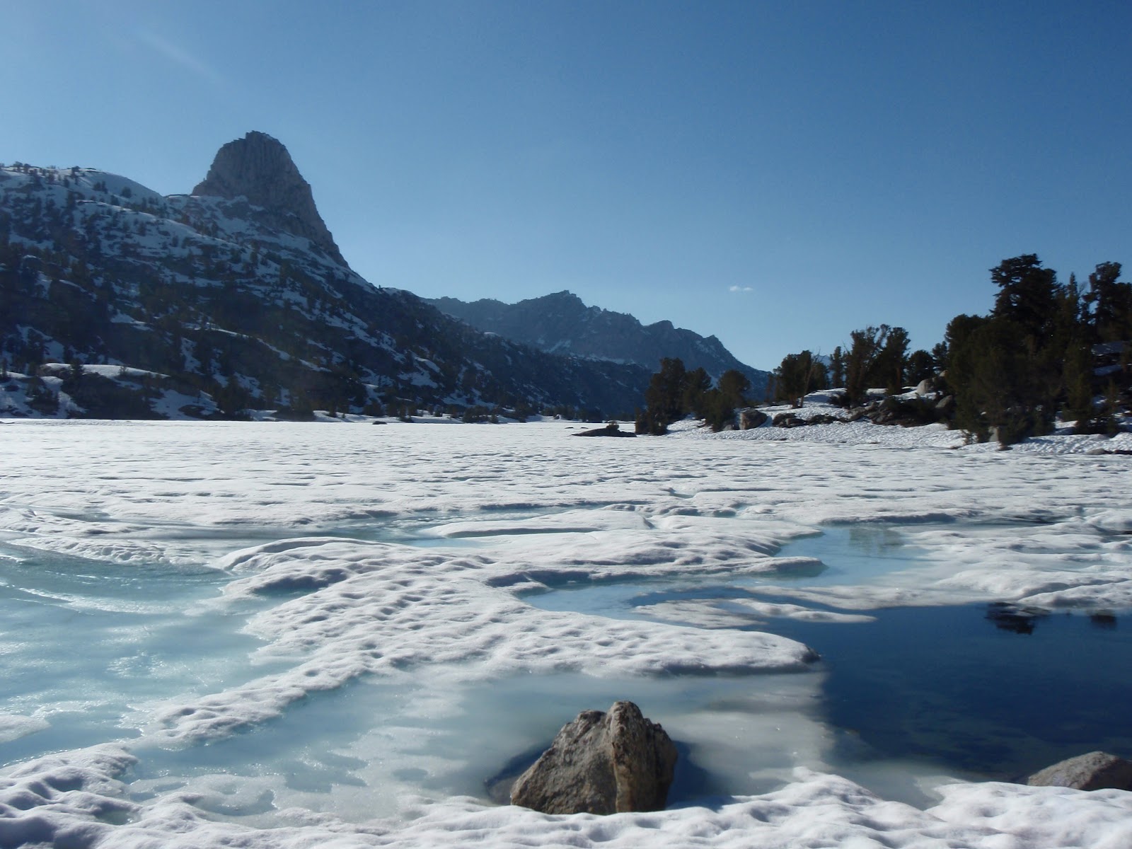
In order to take advantage of the hard snow in the morning again, we woke at 4 AM and started the climb to Mather Pass. An extremely cold South Fork King River crossing and a long haul across a desolate, sun-cupped snow field, and we were at the base of the pass. With our ice axes and microspikes, we slowly stepped up the icy face, rock scrambled across cliffs, and very cautiously skirted the vertical ice shelf to the top of the pass at 12,100 feet. After a failed attempt at glissading on the hard, icy slopes, we strapped on the spikes again and traversed down from the pass, going by the gorgeous Palisade Lakes and down the Golden Staircase (the last section of the JMT built) to the North Fork King River. A short 3 miles uphill past flooded Grouse Meadows brought us to a cozy camp in a lodgepole pine forest, along a rushing creek.
19 miles, 831 miles S->N
 |
| Sun Cups |
 |
| Adam Crossing Snow Bridge |
 |
| Mather Pass |
|
|
 |
Forest Ascending the Near Vertical Mather Pass |
 |
| The Golden Staircase |
 |
| Shooting Star |
 |
| Sometimes the PCT is More like a River than a Trail |
6/24
Happy Birthday to Forest's Mom and Adam's Dad today! Hope you both had wonderful birthdays in New York with Dad and Kes (Linda) and eating Ruffles and drinking grape Koolaid (Dave)! We got another 4 AM start to get up and down Muir Pass before the snow softened up. Along the 7 mile climb, we spooked up 2 black-tailed bucks, ran into Hobbs (a friend) furiously slinging rocks at a persistent marmot, and met some new and old friends above the tree line. We reached the Muir Hut summit (11,955 ft) at 8:30 AM. In memory of John Muir, the stone hut was constructed as an emergency shelter for those in need. After a snack and relaxing break in the sun, we cruised downhill all day to Evolution Creek that we crossed in the meadow to avoid the dangerous, cold, swift channel. Down another 1,000 feet along the rapids and falls of Evolution Creek and among some massive Juniper legends to the banks of the San Joaquin River for camp.
20 miles, 851 miles S->N
 |
| Approaching Muir Pass |
 |
| Muir Pass- Forest and Friend Colin are the Small Black Dots Near the Center of the Picture |
 |
Forest and Friends Relaxing at Muir Hut |
 |
| Descending from Muir Pass |
 |
| Evolution Meadow |
 |
| Forest Overlooking Evolution Creek |
 |
| Cascades of Evolution Creek |
 |
| San Joaquin River |
6/25
4 AM came way too early! Walking by 5, we strolled gently downhill along the San Joaquin River for 7 easy, quick miles. After a short break and snack, we climbed for the next 6 miles summiting Selden Pass (10,900 ft), our easiest yet, with 4 other thru-hikers. After a Nutella and PB sandwich, we descended in fear of what crossing Bear Creek was going to be like. We got a laugh along the way, as Adam fell completely in a posthole. 6 feet deep! With nothing hurt, we pushed to Bear Creek, an icy, waist deep, strong river. We crossed in tandem by putting our arms around each other and through the back of the pack. This made for a very solid shuffle as we share points of contact with the river bottom. After drying out and warming up from the 38 degree soak, we pushed on, climbed another 1000 ft and camped at 9900 ft, on a beautiful ridge. 22 well earned PCT miles; S->N 873.
 |
| Marmot Posing on Selden Pass |
 |
| Adam with a Smile after a Lucky 6 foot Posthole! |
6/26
After a brisk evening, we got moving at 4 a.m. once again. This time we were up early to hit the rivers before the sun filled them with snow melt. 7 miles of downhill rock scrambling and a short ascent brought us to our first Mono Creek crossing. It looked quite tame. Wow, were we ever wrong! Both of us already halfway across, we were belly button deep in icy, rushing water. We both were fortunate to have a tree limb to grab and drag ourselves out of the torrent. Quite humbled, we shook it off and moved on to the next Mono crossing. This time, we were smart about it and patrolled the shoreline until we found a combination of shallow water and boulders and logs to cross on. An easy crossing below the cascades of the Silver Pass Creek and a 3 mile incline through snow led us to the 10,900 foot Silver Pass. We dried out our gear from the river crossing and had a quick lunch before gaping and glissading past many lakes down to the Fish Creek bridge. A steep climb and a steep descent down to Purple Lake, and we set up camp after an exhausting day of trudging through the snow. A meal of stuffing and potatoes were the knock out punch before passing out in our luxurious tent. 20 miles; S->N 893.
 |
| Mono Creek Bridge |
 |
| Crossing Silver Pass Creek Cascades |
 |
| Adam Preparing Dinner |
 |
| Purple Lake |
6/27
With town food and a day off on our minds, we got up at 4 AM and cruised an easy 14 miles, down to Red's Meadow. Due to the record snow this year, the store and bus were not yet open (very disappointing). We took a small detour to Devil's Postpile National Monument, a series of incredible rock outcroppings formed through volcanism and glaciation (
Click here to read about the metamorphic hexagon pillars). We caught a ride on a training bus to the Mammoth Ski Lodge. After a lousy, expensive lunch and a $5 shower at the lodge, we hopped on the bus to the Mammoth Village, where our friend Jarad Barkeim picked us up. We downed a Mammoth-sized pizza and headed to Jarad's mustard colored Econoline van at the pack camp, where Jarad's 14 Civilian Conservation Corps members were getting prepared to head to the backcountry tomorrow for a summer of trail work. Well, past our bed time at 9 p.m., we passed out in Jarad's Subaru.
 |
| Devil's Postpile |
 |
| Jarad's Home |
6/28
Today, we are cruising around in Jarad's Subaru doing our chores and getting ready to get back on the trail tomorrow. A massive THANK YOU to Jarad for the coffee, oatmeal, and egg breakfast in the luxury van and for allowing us to use his car for the day. Jarad left this morning for the backcountry with his crew. Have a great summer and we hope to see you in the fall! Thanks again.
Itinerary:
Possible trip to Yosemite Valley --July 2-4
Bridgeport, CA -- July 8
South Lake Tahoe, CA -- July 14
Despite the challenges ahead and behind us, and hearing stories of friends that have left the trail, we will continue to walk North for AmeriKids. Please help support Camp AmeriKids and stay tuned for more updates!
Spread the word. Spread the love.
Much love,
F + A


Forest,
ReplyDeleteCathy has been keeping me informed of your progress.
What an adventure!
And what a wonderful thing to do for yourself and those you love.
I trust that the planning, perseverance, connections and just plain fun will set the pattern for your life.
Les Troy