For unfortunate reasons our stay in
Mammoth Lakes was extended, and we found ourselves zeroing on 6/29 and 6/30. For the past 80 miles, Adam had been suffering from intense soreness in his right knee and
Forest from an infected hangnail in his toe. As you can imagine, walking on either of these injuries was difficult. Thankful to have Jarad’s car, the stay in Mammoth went quickly, although town stays of this magnitude for a couple of starved hikers can and did get quite expensive.
Forest got his ingrown toenail surgically removed, and we waited out a snow storm in the mountains. In the long run, it was probably to our advantage to be stuck in a town at this time.
7/1
Our journey resumed on the first day of a new month, waking at the Motel 6 at 8 AM and finally getting out of Mammoth around noon. After a quick trolley, bus, and bus ride, we were back at the Postpile, eager to once again enter the High Sierra. The day proceeded uneventfully as we climbed from the Postpile to Agnew Meadows—generally in patchy snow—and from Agnew up nearly 1500 feet to our camp aside a lakelet. A quick stuffing/tuna dinner followed by some stretches, and we were in our tent early after a day that was more mentally draining (due to the logistics in Mammoth) than physically.
14 PCT miles after 12 PM, 921 SàN
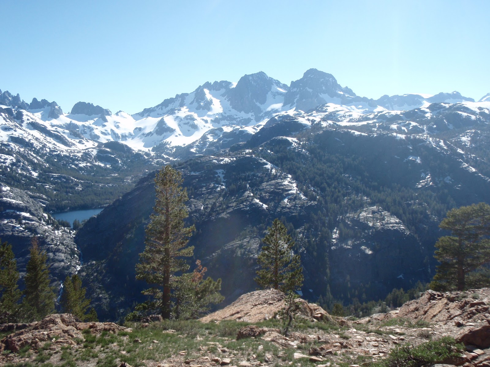
![]() |
| Ritter Range |
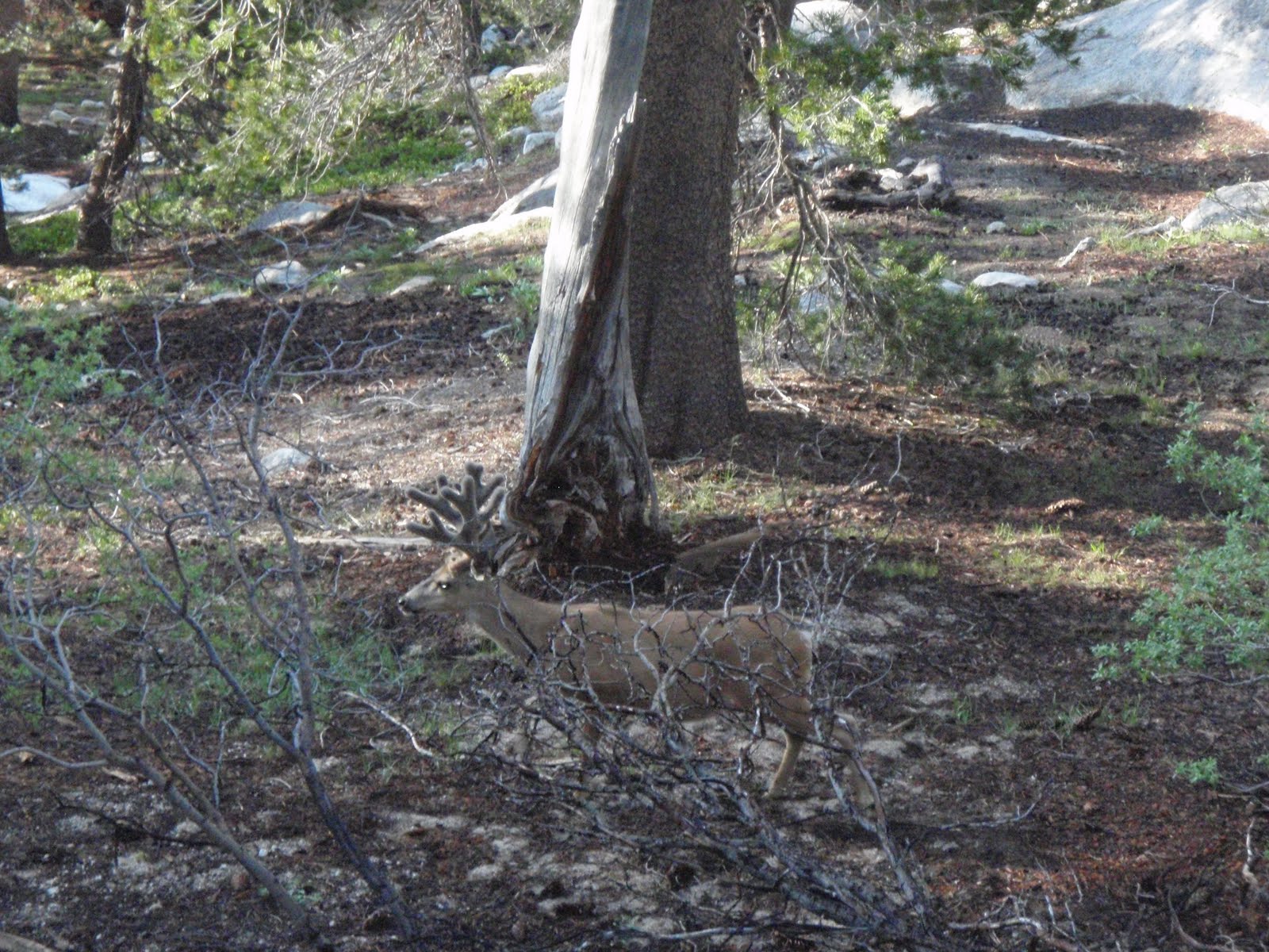
![]() |
| Curious Fella |
7/2
The day seemed simple enough. The plan was to wake early, scamper up and over Island Pass (elevation 10,200 ft), drop to cross Rush Creek, climb 1500 feet to summit our final 'true' High Sierra pass, Donahue (elevation 11,000 ft), drop 2500 feet into Lyell Canyon, and walk the beautiful, level 8 miles along Tuolumne Meadows to the Tuolumne Meadows Campground. Plans altered first, as we slept in an extra hour and a half, waking at 5:30 AM. No harm done. Second, as Adam was descending from Island Pass, he fell and sprained his ankle as bad as he ever has. Cursing followed and after a short breather, we climbed on, anxious to tackle the pass before the ankle found out our plans. We summitted around noon, taking a long lunch break to soak up the beauty and talk with some John Muir Trail hikers. We then started our long rapid descent into Lyell Canyon around 1 PM. Losing the trail, but knowing it followed the river, we basically climbed carefully down the side of a rocky cliff (Adam falling twice more) and found it at the canyon floor. Rather than wait until morning to get to the campground, we walked the remaining 8 miles tonight along Tuolumne Meadows, a treeless expanse of Sierran beauty split lengthwise by the clear Tuolumne River and surrounded by jagged granite peaks. We arrived at the campground at 7:30, hours after we had planned, ate a dinner of potatoes with bacon bits and Ramen, a desert of no-bake cheesecake, and said goodnight to this crazy day at 9 PM. 20 PCT miles, 941 S->N
![]() |
| Tuolumne Meadows |
7/3
We woke at 6, dried our gear of the condensation, and headed to the bus stop to catch a ride to the much anticipated
Yosemite Valley. Learning that there may or may not be a bus, we decided to hitch. We caught a ride from an awesome teenager named Ian, who was on a solo trip hiking and snowboarding in the area. We discovered that Ian was far wiser than his years and during our 50 mile hitch into the Valley, he named every peak and waterfall. A great tour and an awesome guy. Thanks a lot Ian! Forgetting about the holiday weekend or at least trying to be oblivious to it, we were in awe at what we saw in the Valley. Cars lined every road and thousands of tourists could be seen across the hillsides. This was not the
Yosemite we expected. Shuttles were packed like a sardine can, waste baskets overflowed as park service tried to keep up, and the lost boys (Bert & Ernie) sat bewildered on the deck of the food court. To make matters worse, temperatures soared above 90 degrees. We promised each other to come back and see the Valley under different circumstances. After battling crowds, we actually found a quiet place to camp and spent an hour talking with fellow vagabonds about our journey. Before we passed out for the night, we spent quite some time lying on a bridge, looking up at an incredible Sierran starlit night, trying to comprehend just how big the universe is.
![]() |
| Cathedral Peak |
![]() |
| 2 Dorks and Half Dome |
![]() |
| El Capitan |
![]() |
| Upper Yosemite Falls |
![]() |
| Half Dome |
7/4 Happy Independence Day!
Anxious to start the day right, we quickly woke and wandered to
Curry Village for a breakfast buffet! Buffets always lose money to PCT hikers. Forest prepared to
hike Half Dome, regarded by John Muir as “the most beautiful and most sublime of all the
Yosemite rocks,” and Adam moved camp to a new location. Adam skipped the hike and seated himself for the rest of the day upon a downed lodgepole pine, soaking his ankle in the cold river, writing, and reading John Muir’s “My First Summer in the Sierra” –fitting to say the least. He was nearly knocked off his perch when a watersnake decided to use his soggy foot as a stronghold to escape the current. It moved on and attached itself just 3 feet away, with the help of an eddy, to the same log Adam was sitting on. After a mutual agreement via a long staredown that he wasn’t up to any funny-buisness, Adam’s leg reentered the water and the snake hung out for 30 minutes.
Meanwhile,
Forest was flying up to Half Dome with just a few snacks and some water on his back. Amazed by the ease and enjoyment of the light load, Forest cruised up the 8.5 mile, 5000 foot climb in about 2.5 hrs, passing by raging waterfalls and hundreds of tourists (very few after the first 2.5 miles from the road), as well as scaling the near vertical granite face of Half Dome. The last push to the summit involves a gnarly cable handrail to pull yourself up to the top, while you are surrounded by granite cliffs that offer a 5,000 foot free fall back to the
Yosemite Valley. Most people wear gloves and clip themselves onto the cable with a beaner and rope for safety in case of wind gusts or a slip on the smooth granite (which
Forest was unaware of until reaching the cables). Despite the traffic jam, Forest pulled his way up to the summit to be fully rewarded with views of multible falls, peaks, domes, and the entire
Yosemite Valley below! A few photos on the “diving board”, water, and a couple hours of soaking it all in, and
Forest headed down the gut wrenching cable descent. What a rush! A few friends were made on the decent before
Forest let momentum carry him down to the Mist Trail and down to the valley floor. The “Mist” Trail, due to extreme snowmelt, was actually quite the welcomed dowsing of frigid water after a hot day in the sun! After the 20 mile day hike and the day on the river with friend snake, we both headed to the dinner buffet and consumed until ill. We then crashed a
Yosemite Valley staff gathering and relaxed under the stars on our favorite bridge with our new friend, Angie.
![]() |
| Forest Atop Half Dome |
![]() |
| Cable Climb Up to Summit |
![]() |
| Down the Cables |
![]() |
| Falls Along the Mist Trail |
![]() |
| Rainbow in Mist/Soak Trail |
7/5
We were surprised and woken by a hungry black bear wandering through a cluster of exposed PCT hikers cowboy camping next to us. Some yelling and screaming, they chased the little guy/girl off temporarily before he/she returned to make another pass. A lazy morning of eating oreos, bagels/cream cheese, phone calls, and checking our emails and dissolving bank accounts.... Our friend Angie joined us for pizza and a relaxing afternoon by the
Merced River. Angie, best of luck with the start of the season in Tuolumne and it was a pleasure to have such an amazing person to “guide” us around
Yosemite and the mud holes. On a bus back to Tuolumne Campground for the evening, and we resided to our tent after a Ranger informed us that there are some extremely grumpy bears that have been causing problems in camp… We will see what tonight brings.
7/6
After a few relaxing days in the
Yosemite Valley, we were back on the trail for one of the most feared/highest risk sections of the entire PCT. With multiple fierce rivers to cross and few tracks to follow, we were in for a slow moving, challenging 77 miles. We traversed down canyon along the Tuolumne River, getting misted by white cascades, and arrived at the feared McCabe and Return Creeks that have sent multiple hikers back to Tuolumne with their tails between their legs. Meeting up with some other hikers, we scouted down stream and crossed both of the raging rivers on log jams, tree branches, and boulders. Relieved, but concerned with the darkening sky, we moved on to climb a forested pass and soon were getting drenched in a thunderstorm. We slid our way down the steep, soggy slopes to the bottom of
Matterhorn Canyon. We were now faced with the obstacle of finding a safe crossing to the other side of the swelled Matterhorn Canyon Creek. Already drenched from the rain, we finally crossed 3 branches; first a chest deep channel, second, a gnarly half submerged log over deep white water, and third, a shallow riffle. Frozen and soaked, we set up camp as the clouds parted and ate a warm dinner before jumping into our damp sleeping bags for the night. 23 PCT miles, 963 S->N
![]() |
| Tuolumne Falls |
![]() |
| Storm Brewing |
7/7
We woke cold and wet, but were pleased to hit the trail with clear skies. About a half mile in, we met Sly, another thru-hiker from
Wisconsin. The three of us climbed up
Wilson Canyon and up to Benson Pass. With all of our gear soaked, we took a break to lay everything out in the sun. We moved on down canyon for an afternoon of crazy river crossings, once again. We crossed the outlet of
Smedberg Lake 2 times before we reached the canyon floor. A half mile later we were working our way across the wide, deep, multi channeled Piute Creek, which was about 100 yards across. Back on the trail (more like a river), we climbed 1500 feet to
Seavy Pass. The next four miles were possibly the most grueling yet, as we traversed the steep snow slopes above the raging Kerrick Canyon Creek. Finally, we intersected the raging body of water to be rewarded with our most dangerous river crossing on the PCT so far. All of us, one at a time, crossed the slick log that was under about 2 feet of white water with the center being smacked with a pulsing surge of water. Exhilarated to be on the other side of the river (and alive), we changed our wet clothes and settled in for a hot meal and into the tent. 18 PCT miles, 981 S->N
![]() |
| The Boss |
![]() |
| Nimble Foot or Big Foot? |
![]() |
| Kerrick Canyon Crossing |
![]() |
| Where's that log? |
We woke at 5 and learned a valuable lesson. The water had dropped over night, due to frozen snow pack up-canyon and we could see underneath the log! We will be smarter about our river crossings in the future. This section of the PCT is characterized by canyons and rivers, and this day was no exception. We would climb 1,000 feet just to drop 1,000 immediately, and this went on all day. The first climb and descent put us in
Stubblefield Canyon, the site of our first stream crossing of the day. Luckily we found a log to cross the raging river on, but for the second half of the crossing, we were not so lucky. Holding our packs above our heads, we crossed the wide, frigid river at chest depth. Once again, we climbed a ridge and dropped into a canyon next to
Wilma Lake. The next 10 or so miles were the most difficult for us yet. A lingering snowpack without fresh tracks to follow made it very stressful. We also waded thigh deep through muddy meadows. It was very…very…tough walking. We summitted
Dorothy Lake Pass late and quickly found dry ground on the other side. 1000 miles in! 19 of our hardest today.
![]() |
| Following Morning--Lesson Learned |
7/9
Woke at 5 and on the trail by 6:15. The first 6 miles were snow-free…and we flew. We started our climb for the day, losing the tracks of the people in front of us temporarily, but soon picked them up as we crossed a beautiful snowfield to a saddle. After a short break of soaking up this incredible landscape, we ascended 1000 ft, nearly walking vertical. We had to use our ice axes, hopefully for the last time, as we traversed a steep snow covered bowl. After careful steps, we climbed to the crest where we would remain all day amongst
volcanic, lichen-covered pinnacles looking down on
Sonora Pass. The mountains ahead had much less snow, and we breathed a collective sigh of relief. A quick descent with an awesome glissade, and we were sitting at a trailhead parking lot eating fresh fruit and chocolate cake, courtesy of Owl, a trail angel. Thanks Owl! We caught a hitch down to
Bridgeport from a crazy driver named Rolf, ate a huge dinner of burgers, pizza, and salads from Rhino’s Bar and Grill, and crawled into bed at the Bridgeport Inn at 10 PM, sharing a room with Sly. 18 PCT miles, 1018 S->N
![]() |
| Steep Traverse Across Snow Field |
![]() |
| No Snowmobiles! |
![]() |
| Lichen |
![]() |
| Sonora Pass with Sly |
![]() |
| Owl's Trail Magic Cafe |
7/10
Sly, Bert, and Ernie all rose quite early this morning, as we all were excited for the all you can eat pancakes and coffee at Pop’s in
Bridgeport. We resupplied and caught up with friends, Mr. Furious and Turbo. We said goodbye to Sly and headed over to a burger joint for burgers, fries, and malts before heading up the road to hitch back to
Sonora Pass. We caught a ride from a nice couple that section hikes the PCT and then caught another ride with a Swiss guy roadtripping on holiday. We thanked Owl for the trail magic and hit the trail. After a few miles, we took a break to rock climb and chill out on some awesome volcanic pinnacles. We never again will reach 10,000 feet on the PCT. A long, snowy descent to level ground near
Wolf Creek, and we set up at dusk. 7 PCT miles, 1025 S->N
7/11
We woke to a cold morning on the edge of
Wolf Creek at 5:30 AM, descended along it, and finally warmed up just before a 1,000 foot climb. Lost near the top but eventually finding our way, we crossed many saddles (low point between two peaks). We made it down to Boulder Creek, but took
Boulder Lake Trail instead of the PCT, a 1.5 mile detour. Instead of backtracking, we climbed up the boulder choked creek and luckily found the trail. The afternoon found us getting lost a lot, as we had only one faint track to follow through the snow. Descending hard, we crossed 3 branches of Wolf Creek and eventually summited Wolf Creek Pass. Descending form the pass, we had dinner at
Noble Lake and at 7, continued moving. Feeling great after the food, we walked another 3 miles to a dry patch of ground surrounded by snow and called it a day. 24 PCT miles, 1049 S->N
7/12
Today was a day full of welcomed change on the PCT. Early into the hike, we were out of the snow and walking on dry ground through meadows full of wildflowers. The mountains have transitioned a gread deal from granite peaks to volcanic domes and pinnacles. We cruised through Raymond Meadows and back into the trackless snow on a climb up to The Nipple (no joke, that is what it is called). Once again, we lost trail in the snow that we hoped we were done with, but after a short break and a snickers, we climbed over a steep ridge to find The Nipple hovering above us across a saddle. We passed by the massive
Blue Lakes and meandered down to the
Lost Lakes. Soon after, we cooked up a pot of mashed potatoes with bacon bits before cruising across the snowfield and up the pass along Elephant’s Back. We were rewarded with a gorgeous sunset and moonrise atop the pass. We dropped down to
Carson Pass for camp and feasted on our extra cookies, bars, and peanut butter before hitting the sack. 30 PCT miles, 1079 S->N
![]()
![]()
![]() |
| Volcanic Pinnacles above Raymond Meadows |
![]() |
| The Nipple |
![]() |
| Blue Lakes |
![]() |
| Moonrise from Elephant's Back |
7/13
We rose a little later than usual (6 AM), as we anticipated a quick 14 miles to HWY 50 today. We were
misled. After getting lost a bit and trudging through the snow for 7 hours, we finally made it to the busy highway. 45 minutes later, we were cruising the 11 miles to
South Lake Tahoe with a flight attendant. First stop in town…the supermarket for food and beverage. We grabbed a cheap room and relaxed before heading to the All-You-Can-Eat Buffet at the casino on the Stateline. Of course, we went back to the room ill after OVERconsumption, but we needed the calories. A dip in the hot tub and some TV time rounded out our day. 14 PCT miles, 10 plates of buffet, 1093 S->N
7/14
Today we have been scrambling around
South Lake doing laundry, resupplying, shoe shopping, blogging, and eating. We plan to get back on the trail early tomorrow morning.
It has been quite the grind lately with all the snow, but we keep pushing on to get out of it and closer to
Canada. We will post an itinerary in
Sierra City, our next stop, hopefully in about 5 days.
Thank you for all the support and we will be in touch soon.
Spread the word. Spread the love.
Much love,